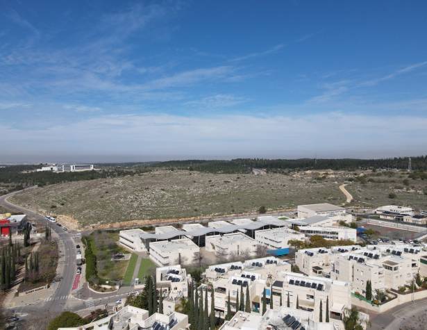
On 5.3.25, the Modi'in Maccabim Re'ut City Council, in its plenary session of the Local Planning and Building Committee, recommended the submission of the local outline plan for the Mayanot neighborhood, located west of Kramim neighborhood.
This will be the first neighborhood to be established as part of Phase II of the city, according to the comprehensive outline plan, MD/2040.
Mayor Haim Bibas: "Modi'in Maccabim Re'ut continues to grow and develop with careful planning that balances expanding residential options, developing employment areas, and maintaining the quality of life and green spaces. The new Mayanot neighborhood is a significant step in the city's expansion process, and it will provide diverse housing solutions, while maintaining the community and the unique character of the city.
One of our main goals is to enable the city's citizens to continue living here, close to their families, and therefore we are promoting construction that includes affordable housing alongside advanced planning of educational, transportation, and recreational infrastructure.
Our vision is clear: a smart, green, and well-planned city that continues to set high standards in quality of life and urban innovation. We will continue to develop new neighborhoods, strengthen the connections between the city and its surroundings, and ensure that Modi'in Maccabim Re'ut remains a leading city - for this generation and generations to come."
Mayanot is located west of the Kramim neighborhood, and will create a continuation of it. The northern border of the new neighborhood is Highway 443, its southern border is Emek HaEla Blvd., and the western border will be the city's western entrance road, Yehuda HaMaccabi Blvd. The neighborhood is spread over approximately 600 dunams.
According to the planning, Mayanot neighborhood includes approximately 3,200 housing units. Similar to the Moreshet neighborhood, 30% of the number of units in this neighborhood, approximately 1,200 units, are designated for affordable housing in a variety of three-, four-, and five-room apartments. At least 25% of them, approximately 300 units, are designated for city residents.
The neighborhood, which is still in the planning stages, is intended to house approximately 10,500 residents. Accordingly, buildings for elementary and secondary schools will be built there, as well as kindergarten complexes, daycare centers and synagogues.
The neighborhood's construction types include residential buildings between five and nine stories high. Similar to the Moreshet neighborhood, some of the construction in the neighborhood will be mixed-use, with the ground floor on the main streets accompanied by a commercial front. In addition, within the scope of the plan, buildings for employment with a commercial front on the ground floor are planned.
The neighborhood is planned to have 4 entrances and exits from Yehuda HaMaccabi Street, Emek HaEla Street and Emek Harod Street.
The main street planned for the center crosses the neighborhood from east to west, and along it commercial, occupational and public uses are proposed. The secondary streets will be designed in a ring structure that will encompass all of the neighborhood's borders. The streets will have bicycle paths for cyclists. Vertical public paths will be placed between the streets, which will provide efficient connectivity between the streets and direct access to residential buildings, similar to the terraced streets in the existing neighborhoods.
The northern area of the neighborhood will be planned to create a buffer between the neighborhood and Highway 443, along with the establishment of parks and playgrounds for residents, scattered throughout the neighborhood, similar to those in the city's older neighborhoods.
The Mayanot neighborhood plan is the first step in the process of expanding Modi'in Maccabim Re'ut in accordance with the city's Phas in accordance with the Phase 2 plans, set out in the comprehensive plan, MD/2040 for Phase 2 of the city: an addition of approximately 39,000 housing units, for a target city population of approximately 240,000 residents.
In addition to the new neighborhoods, according to the new outline plan, approximately 1.7 million square meters will be built in Phase 2 of the city for commercial and employment space. The plan includes, among other things, planning for the construction of a general hospital on an area of approximately 150 dunams, an academic center and a mass transit station in the new business district, as well as 15,000 square meters for the construction of a boutique hotel in the technological park complex. The new outline plan also emphasizes preserving the many open green areas that exist in the city, creating an open and high-quality continuity for the KKL-JNF forests that surround the city, establishing a peripheral scenic promenade on the edges of the city, which strengthens the connection between the city and the open areas surrounding it, as well as strengthening and preserving the ecological corridor.


